Loop classic
Best understood as part of a circuit, not a single ascent
The Col du Galibier is one of the great monuments of cycling: high, long, exposed, and woven deeply into Tour de France history.
At 2,642 m, it is frequently the highest point of the Tour de France and one of the most iconic paved passes in the Alps.
The Col du Galibier is located in the south-easternern region of the French Dauphiné Alps, marking the border between the Savoie (Auvergne-Rhône-Alpes) and the Haute-Alpes (Provence-Alpes-Côte d’Azur).
Linking the Maurienne valley with the Briançonnais, it forms a legendary alpine sequence with the Col du Télégraphe from the north and the Col du Lautaret from the south.
The tunnel at pass height is at 2,556 meters and that used to be the only through road until 1976. When the tunnel was closed for restoration, a loop around the summit similar to the one over the Bonette, was constructed. This reaches the ‘official’ summit of 2,642 meters.
Why ride the Col du Galibier?
What distinguishes the Galibier is not brutal steepness, but length, altitude and exposure. Effort builds slowly over many kilometers, air thins above 2,000 m, and weather can shift rapidly even in midsummer.
- A true cycling monument: Few climbs combine history, altitude and scale so completely
- High‑mountain immersion: Above treeline for long stretches, with vast alpine amphitheatres
- Multiple classic combinations: Télégraphe–Galibier, Lautaret–Galibier, Marmotte‑style loops
- A milestone ride: For many cyclists, the Galibier is a once‑in‑a‑lifetime ascent
Riding the Galibier is as much about context and atmosphere as Watts and gradients.
Seasonal notes
Due to its altitude and fully exposed summit section, the Col du Galibier is closed for much of the year.
The road usually reopens in two stages: the tunnel below the summit typically opens in late May or early June, while the summit road used by cyclists opens 1–2 weeks later, most often in early to mid‑June depending on snow conditions.
The pass normally closes again in mid to late October, though early closures are possible after autumn snowfall.
Even in peak summer, conditions can be harsh. Temperatures at the summit are often more than 15 °C lower than in the valleys, and wind, fog, or sudden storms are common. Snowfields frequently remain alongside the road well into July, and weather can change rapidly within minutes.
Warm layers are essential for both the climb and – perhaps even more – the descent. Before riding, always check live road status for both sides, as opening and closing dates, and weather conditions can differ by approach.
Tour de France
The Col du Galibier was first cycled in the Tour de France in 1911 and has been a regular appearance in a Tour stage ever since.
With a total of 64 appearances, it’s only surpassed by the Col du Tourmalet.
It has also been crossed twice in one Tour, in 2011’s 100th-Anniversary edition, with the only summit finish on the Galibier in the Tour’s history, and in 2022.
A 2015 double was cancelled due to the collapse of the Chambon tunnel in the Lautaret descend.
In the last stretch towards the tunnel, coming from the south, there is a monument in honor of Henri Desgrange, instigator and first director of the Tour de France.
The memorial was inaugurated in 1949 and whenever the tour crosses the Col du Galibier, a wreath is laid on the memorial.
Souvenir Henri Desgrange
The first rider to cross the summit of the Galibier when it is in a Tour stage, will get the Souvenir Henri Desgrange.
First awarded randomly, later exclusively tied to the Galibier being present in the Tour, the rule now is that the award is given to:
- the first rider to pass the summit of the Galibier if it is in the Tour, regardless of higher cols
- the first rider to pass the highest col in that year’s Tour if it is not.
Because of this rule, of the three French cols that are higher than the Galibier – the Iseran, Agnel and Bonette – only the Iseran has been awarded the Souvenir once.
The Tour has crossed the Agnel and the Bonette several times, but the Galibier was in those Tours also.
Note that the Souvenir can be awarded to a highest summit outside France, as has been the case with Port d’Envalira (Andorra) three times.
The Col du Grand-Saint-Bernard on the Swiss – Italian border has also been awarded the prize, the Tour approaching it from the Swiss end in 2009.
Profiles
Saint-Michel-de-Maurienne (North)
- Start: Saint‑Michel‑de‑Maurienne (≈ 720 m)
- Sequence: Col du Télégraphe → Valloire → Col du Galibier
- Total distance: ~35 km
- Elevation gain: ~2,100 m
This is the classic approach, used by the Tour de France since 1911. The Télégraphe (11.9 km at ~7%) serves as a long prelude before the main climb from Valloire.

Télégraphe
At 12.1 kilometers in length, with an elevation of 852 meters (7%), the preceding Télégraphe (1,566m) is not to be mistaken as merely a warming up for the Galibier.
The 4.7-kilometer-long descent into Valloire, has its own segement going in the opposite direction.
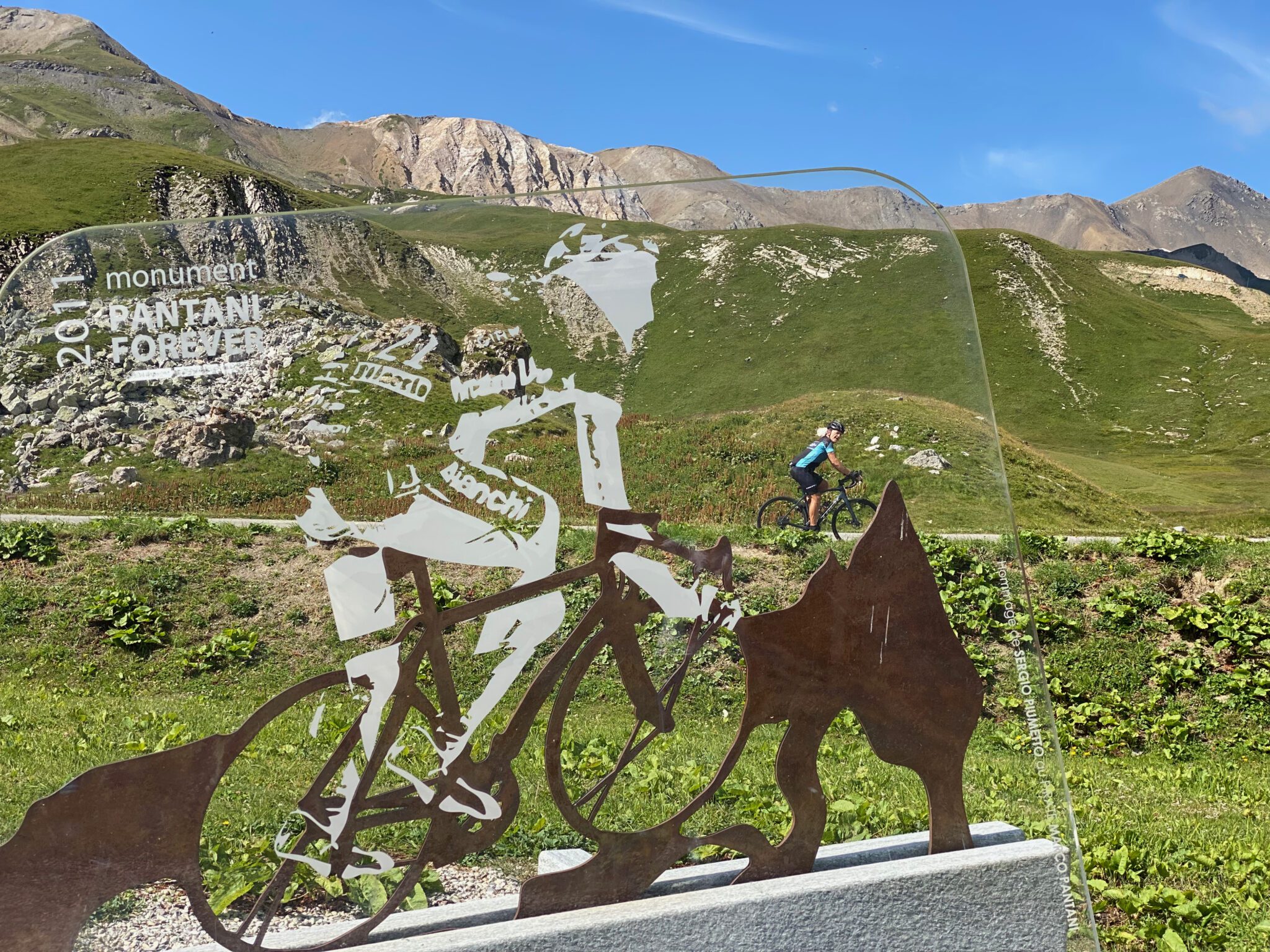
Pantani Monument
About halfway up the final, some 4 kilometers from the tunnel, there is a monument in honor of Marco Pantani. It’s located at the right side of the road and you may miss it if you don’t know where to look, as it is a positioned in a field just off the road.
As soon as you reach the scattered buildings at Les Granges, you’re near it.
Bike Rebel Ascents
I tackled the northern ascent in 2014, as well as when I combined it with the Lautaret from Briançon in 2017.
I revisited the Galibier from the north during my Tour de France 2021 when it was in my Marmotte, albeit I started and ended that in Saint-Jean-de-Maurienne.
Briançon (South‑east)
- Start: Briançon (≈ 1,326 m)
- Sequence: Col du Lautaret → Col du Galibier
- Galibier segment: ~8.5 km
- Elevation gain (Galibier only): ~585 m
The most accessible option, starting high and climbing only the final section from the Lautaret. Despite its shorter length, gradients are sharp near the summit.

To the summit of the Lautaret, the approach from Briançon is 27.7 km long at an average of 3.1%.
Le Clapier (South‑west)
- Start: Le Clapier (≈ 750 m)
- Sequence: Le Capier → La Grave → Col du Lautaret → Col du Galibier
- Total distance: ~48 km
- Elevation gain: ~2,300 m
A huge alpine approach combining scale and scenery. Traffic can be heavier up to La Grave, but the final Lautaret–Galibier section is wide open, dramatic and unforgettable.

The ascent of the Lautaret from le Clapier is 34.1 kilometers long at an average of 3.9%.
Bike Rebel Ascents
The Briançon end was in my Tour de France 2017.
The Galibier from Le Clapier was my first ascent in 2012, when the final loop was closed from the Valloire end. I also cycled this end in 2022, but from Mezoën after a few detours.
Side-by-side
| Side | Character | What it feels like |
|---|---|---|
| North | Long, cumulative, historic | A slow-burning test of pacing; fatigue arrives before altitude does |
| South‑east | Shorter, steeper finales | Pure high‑mountain atmosphere with sharp ramps near the top |
| South‑west | Epic, scenic, committing | A full‑day Alpine ride with vast open landscapes |