
High-altitude giant
Altitude and exposure define the experience more than gradient
Situated in the southern Alps, deep in the Mercantour region, the Bonette feels remote in a way that very few major Alpine climbs still do. Long approach roads, vast open landscapes and a distinct lack of “pass traffic” give it a character that is very different from the northern Alpine giants like the Galibier or Iseran.
This is not a climb of brutal gradients or constant switchbacks. Instead, the Bonette challenges you through length, altitude, exposure and isolation—and that is exactly why it deserves its place in any serious Alpine itinerary.
The Bonette connects the Ubaye Valley in the Alpes-de-Haute-Provence to the Tinée Valley in the Alpes-Maritimes.
The pass is part of the Route des Grandes Alpes, between Lac Léman (Geneva) and the French Riviera (Menton), although it’s labeled a (tough) “alternative” if you choose to ride it instead of the Cayolle.
It’s also part of the Brevet de 7 Cols d’Ubaye, which I obtained in my (first) Tour of 2014.
The Highest
The col itself tops out at 2,715 metres, which already makes it one of the highest true mountain passes in the Alps. However, a loop road—the Cime de la Bonette—rises above the pass to 2,802 metres.
Therefore, in carefully ambiguous wording, the French claim “Route de la Bonette” is “La plus haute d’Europe”, the highest (route) in Europe. But the Cime is not the highest if unpaved through roads and dead ends are included.
From a cycling perspective it is best understood as an optional extension, not the core climb. You reach the col first; the final loop is a bonus—scenic, spectacular, and entirely avoidable if conditions or legs say otherwise.
Why ride the Bonette?
You ride the Bonette not for hairpin drama or iconic signposts, but for scale and solitude.
- It is one of the few Alpine climbs that still feels genuinely remote
- Traffic is low compared to most Tour‑de‑France‑famous passes
- The landscape shifts from forest to high alpine emptiness in a way that feels gradual and earned
- The altitude is real—bad days at the top are not theoretical
Unlike many famous passes, there is no sense that the Bonette exists primarily to serve a race or event. It feels like a road that happens to be there, far from everything else, waiting for those prepared to go and find it.
I cycled both ends of the Bonette during stage 7 of my Tour de France 2014.
Weather and timing
Like the Iseran, the Bonette is a climb where weather planning matters.
- Cold and wind are common even in summer
- Clouds often sit just above the pass
- Sudden storms are not unusual
- The climb feels significantly harder in poor conditions
Early starts are recommended—not for traffic, but for weather stability.
Tour de France
The pass has featured in the Tour de France only five times since 1962, lastly in stage 19 of 2024’s Tour.
Because of the rule that the award is given to the rider that first passes the summit of the Galibier, regardless of possible higher cols in the same Tour, it has only been awarded the Souvenir Henri Desgrange once, in 2024.
Norths vs South
The northern ascent from Jausiers is the classic and by far the most popular approach.
- Long and steady rather than steep
- Consistent gradients that reward pacing
- Gradual exposure to altitude, which can be deceptive
- Excellent road surface and clear sense of progression
This side suits riders who prefer settling into a rhythm and letting the climb unfold kilometer by kilometer. The difficulty creeps in late, once the road has already committed you fully to the mountain.
The southern approach is quieter, wilder, and psychologically more demanding.
- More irregular gradient profile
- Less visual feedback on progress
- A stronger feeling of isolation
- Often harsher weather and more wind‑exposed
If the north side feels “grand”, the south side feels serious. Not necessarily harder on paper, but mentally tougher—especially if weather starts to turn.
Jausiers

After some 17 kilometers you ride past Lac des Essaupriés and a few kilometers further, you pass the Caserne (Fortin) de Restefond, part of the Maginot defense line.
This is around the 2,550-meter mark and about two tough kilometers from the summit.
There is no ‘refuge’ at the summit.
Saint‑Étienne‑de‑Tinée

Also from this end you’ll pass a former barracks complex, the Camp des Fourches, part of the same Maginot defense line, where the “Diables Blues” were housed.
Not long after that, you reach one of the best viewpoints, marked by an Obelix in honor of General Jacquemot. The view down into the valley is absolutely stunning…
As mentioned above, there is no ‘refuge’ for a snack or a souvenir at the summit.
Bonus
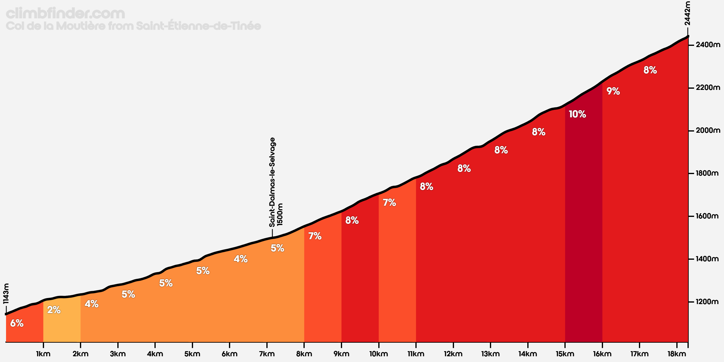
From either end, there’s a road up to the Col de la Moutière (2,452m), which brings you within touching distance of the Bonette.
From Jausiers, you leave the main road at Faux Col de Restfond, 2 kilometers before pass height, and continue on an unpaved road. It is 4 kilometers mostly – steep – downhill, except for the final 500 meters or so.
From the south the road becomes increasingly more degraded after Saint-Dalmas-le-Selvage turning into unpaved / gravel, and that part is not for the faint-hearted either.
There’s also an unpaved road / track between the Cayolle and the Moutière / Bonette. It’s inaccessible on a road bike, but it is part of the Route des Grandes Alpes Gravel…
Background picture: Cime de la Bonnete seen from the south end.
Attribution CC BY-SA 3.0, Link