Valley connector
A functional crossing where the role in the landscape matters
The Col de la Cayolle (2,326m) is a pass in the Southern Alps of France, on the border of the departments of Alpes-Maritimes and Alpes-de-Haute-Provence.
The pass is part of the Route des Grandes Alpes, connecting Lac Léman (Geneva) with the French Riviera (Menton).
The main reason I created this info page, is because it’s also part of the Brevet de 7 Cols d’Ubaye, which I obtained in my (first) Tour of 2014.
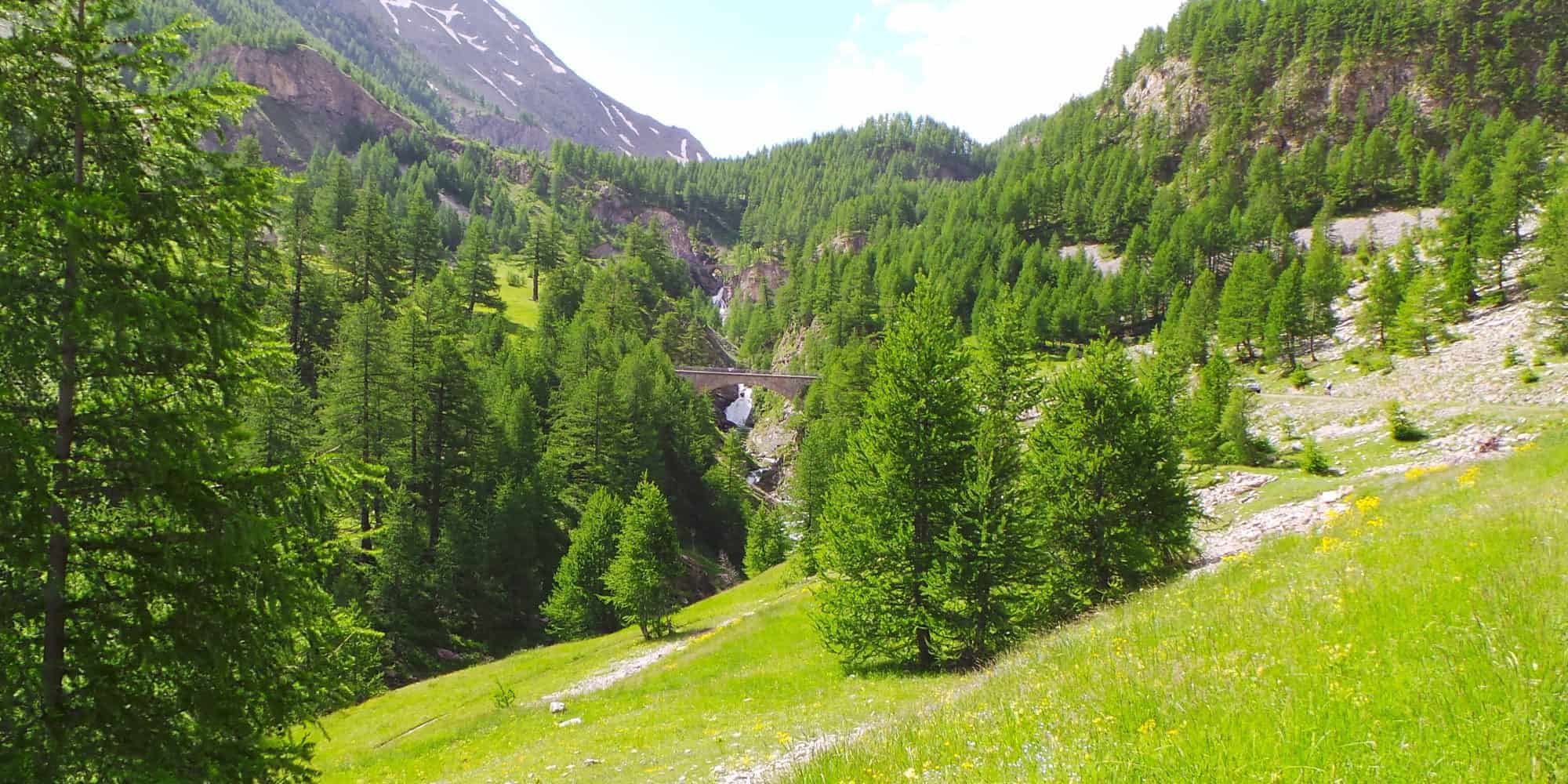
Other than the awesome Bonette, the Cayolle was a favorite, as the road is closed to heavy vehicles and caravans, and it is not suitable for vehicles with trailers or even motor homes.
That means there’s not a lot of traffic – I didn’t even see any motor cyclists during my ascend.
Why ride the Col de la Cayolle
The Col de la Cayolle is a connector in the strict sense, but unlike some crossings, it does not ride as neutral terrain. It links the Ubaye valley with the Var valley, but the experience depends heavily on which direction you approach from.
What sets Cayolle apart is its imbalance of effort:
- From the south, the climb is longer, more sustained, and significantly harder overall, particularly as altitude increases and the road becomes more exposed.
- From the north, the ascent is more gradual and broken, functioning more as a steady transition through terrain rather than a sustained test.
This creates a climb that:
- plays a clear role in route design
- but still demands respect from one side
Cayolle is often used in combination with:
- Col d’Allos
- Col de Vars
- wider Ubaye-based routes
But it is not just a structural link: it is a connector that becomes a proper climb when approached from the south.
For route-building, this matters.
Seasonal notes
The Col de la Cayolle operates on a clear seasonal opening window, as it reaches higher and more remote terrain than nearby connectors.
- Typically closed in winter due to snow
- Opening: late spring or early summer (timing varies depending on snow conditions)
- Best months: June through September
Key considerations:
- Early season riding may involve snowmelt, debris, or partial clearance
- Weather changes can be rapid in the upper sections, especially on the south side
- Traffic is generally limited, reinforcing the sense of isolation
Cayolle should be treated as a seasonal objective, not a reliable access route.
North–south comparison
The Col de la Cayolle does not present two equivalent approaches. While both sides are rideable and coherent, the south side is clearly the more demanding ascent.
North side (Barcelonnette / Ubaye)
- Gradual, broken ascent
- Lower sustained gradients
- Frequent variation in tempo
This side:
- feels transitional rather than demanding
- allows recovery within the climb
- fits naturally into longer, multi-col routes
It is best understood as:
a controlled build-up through terrain, not a defining effort.
South side (Guillaumes / Var valley)
- Longer and more sustained
- Increasing exposure with elevation
- Significantly harder overall
This side:
- behaves like a proper mountain climb
- requires sustained pacing
- becomes more demanding in the upper sections where the road opens out
Unlike the north side:
- there are fewer interruptions to effort
- fatigue builds more consistently
Summary
Cayolle is not a “two-sided contrast” climb in the strict sense—but it is clearly asymmetrical in difficulty:
The north side carries you through the landscape; the south side makes you work for it.
That difference should influence:
- direction of travel
- route planning
- how you distribute effort across a ride
Tour de France
The Cayolle has only featured 3 times in the Tour:
- 1950: first to pass Jean Robic
- 1955: > Charly Gaul
- 1973: > Vicente López Carril
Barcelonnette
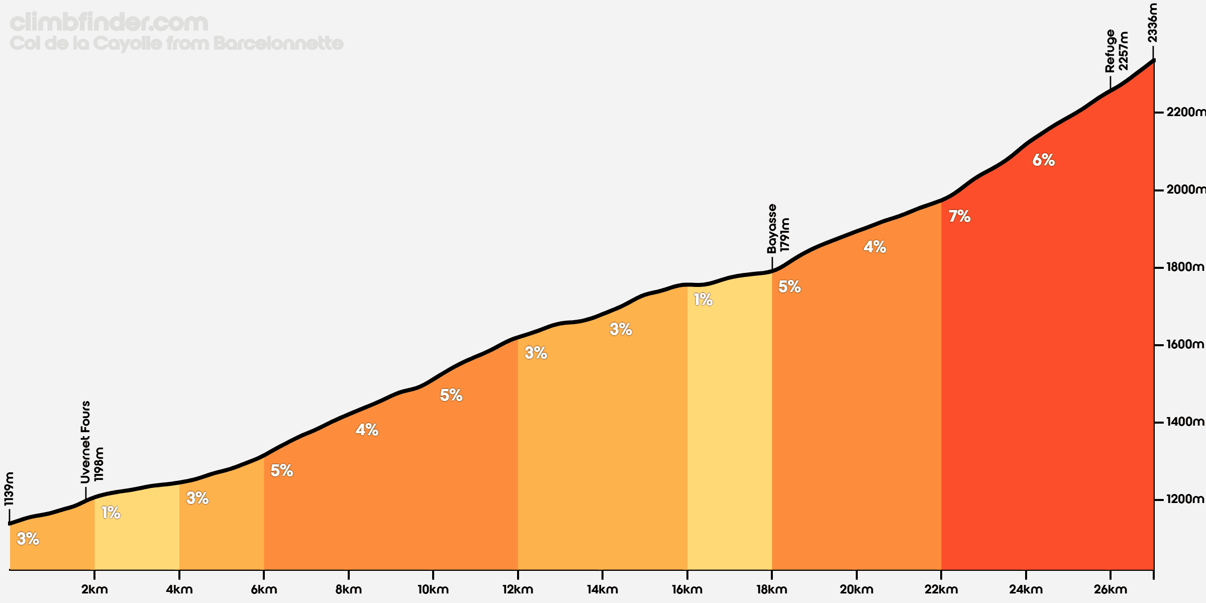
At 27.2 kilometers with 1,198 meters of D+, or 4.4% average, the length is what defines it. Still, with the gradient not exceeding 9%, it’s definitely not a hard climb either and the quiet, scenic road and some jaw-dropping views make it well worth the effort.
There’s an unpaved road / track between Bayasse and the Bonette. It’s inaccessible on a road bike, but it is part of the Route des Grandes Alpes Gravel…
Saint-Martin-d’Entraunes

This ascent is 20.3 kilometers at 6.3%, which means this end is quite a bit more challenging than the northern ascend.
The toughest 5-kilometer stretch is at 7.6%, the toughest kilometer is only marginally harder at 8.4%.