
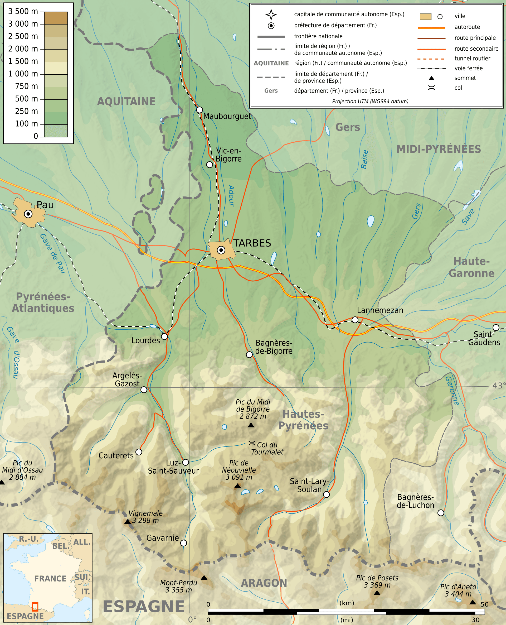
Hautes-Pyrénées is a department in the region of Occitania, southwestern France; Toulouse is its capital.
It is bordered by Pyrénées-Atlantiques to the west, Gers to the north, Haute-Garonne to the east, as well as by the Spanish province of Huesca to the south.
Geography
The Hautes-Pyrénées consists of several distinct geographical areas.
The southern portion, along the border with Spain, consists of high mountain peaks, ranges and groups like the Pic du Midi de Bigorre, Vignemale and Gavernie.
A second area consists of low-altitude rolling hills, broadly speeking above the line between Argèles-Gazost and Bagnères-de-Bigorre.
The northern part of the département consists of largely flat agricultural land, above the line between Lourdes and Lannemezan, with Tarbes in the centre.
The Western Pyrenees National Park, a favorite destination for hikers, covers a significant area, and includes Cirque de Gavarnie and Pont d’Espagne.
The area is also known for its hot springs, and several towns were built around these, most notably Cauterets, Luz-Saint-Sauveur and Bagnères-de-Bigorre.
Popular ski resorts in the Hautes-Pyrénées are Barèges-La Mongie, Gavarnie, Luz-Ardiden, Cauterets, Hautacam, Piau-Engaly and Saint-Lary-Soulan.
And the (Hautes-)Pyrénées is a near-permanent destination on the Tour de France’s itinerary, with significantly difficult passes such as the Tourmalet, the Aubisque and the Soulor.
Cycling the Hautes-Pyrenees
If you’re going to “do” the Pyrenees, this is where it happens.
The Hautes-Pyrénées isn’t just part of the range—it’s the part that defined it.
The climbs everyone names, the roads the Tour keeps coming back to, the place where Pyrenean cycling makes sense.
And still doesn’t behave.
What It Is
This is the central Pyrenees, where the range peaks—geographically and cycling-wise.
It’s where you’ll find:
- The biggest climbs
- The most recognisable names
- The closest thing the Pyrenees has to a “classic circuit”
But don’t mistake that for Alpine-style order, this is still the Pyrenees.
The Feel
This is where the Pyrenees hits properly.
- Roads tighten
- Traffic drops
- Landscapes open, then close again
You’re not riding through a system—you’re moving through terrain that still feels in charge.
Less curated. More alive.
Compared to the Alps
This is the closest the Pyrenees gets to Alpine territory:
- Big climbs
- Big days
- Recognizable routes.
And still:
- Less polished
- Less predictable
- Less crowded
Alps give you consistency, Haute-Pyrénées gives you variation—with just enough structure to stop it being chaos.
Where It Fits
If the Pyrenees as a whole sit awkwardly on the ladder, this is their most “placeable” piece.
- After early Alps → doable, but you’ll feel it
- Alongside French Alps → right level, more bite
- Before the biggest Alpine epics → perfect preparation
Same effort, different demands.
Riding Here
You don’t need to overthink it—but you do need to adapt.
- Don’t expect perfect pacing
- Eat earlier than you think
- Assume the climb will change
Because it will.
Why It Works
Unlike the rest of the range, this area gives you just enough structure:
- You can link climbs.
- You can plan routes.
- You can build proper days out.
But it never feels packaged.
That balance—between iconic and raw—is what makes it work.
The Bike Rebel Take
If the Pyrenees are the alternative to the Alps, the Haute-Pyrénées is the entry point that still feels like the real thing.
It gives you:
- the names
- the scale
- the history
But keeps:
- the unpredictability
- the quiet
- the edge
If you only ride one part of the Pyrenees, it’ll probably be this.
And that’s fine.
Just don’t expect it to behave like anywhere else.
The Climbs
You already know them—or think you do:
- Tourmalet — the headline act
- Aspin — shorter, punchier, no warm-up
- Peyresourde — smoother, but not soft
- Hourquette d’Ancizan — quieter, better than it should be
On paper, they look structured, connected, predictable.
On the road? Less so.
Gradients shift. Effort comes in waves. The climbs don’t always build—they change their mind.
The highest (paved) pass in the area, is the Col du Tourmalet (2,115m) but that was not the highest altitude I reached during my Tour de France 2023.
Even so, looking at the Top 10, ranked by difficulty, I had the feeling beforehand that this Tour would not be any less challenging than my Tours in the Alps.
And it wasn’t.
| Name | Length | Gradient |
| Col du Portet from Saint Lary Soulan | 16.1km | 8.7% |
| Col du Tourmalet | 18.3km | 7.7% |
| Col du Tourmalet from Luz Saint Sauveur via Super Barèges | 18.9km | 7.4% |
| Plateau de Beille | 16km | 7.7% |
| Col de Pailhères | 18.6km | 6.7% |
| Col du Tourmalet from Sainte-Marie de Campan | 16.9km | 7.5% |
| Lac d’Aumar / Lac d’Aubert from Saint Lary Soulan | 25.2km | 5.5% |
| Col de Tentes from Luz Saint Sauveur via Cirque de Gavarnie | 30.1km | 5.1% |
| Col de Mantet | 21.1km | 6.2% |
| Col de Pailhères from Usson-les-Bains | 15.5km | 7.7% |
Map with cols in the area, almost all of which I cycled; the Aubisque’s summit is in the Pyrénées-Atlantique, but the Argelès Gazost end starts in the Hautes-Pyrénées: