Historic crossing
A route shaped by history as much as by terrain
The Col du Mont Cenis / Colle del Moncenisio (2,083 m) is one of those Alpine crossings whose significance predates cycling by centuries, linking the Maurienne in France with the Val di Susa in Italy. The pass itself is entirely on French territory since 1947, but it functions as a transalpine crossing with two very different approaches.
Why ride Mont Cenis
Mont Cenis is not a dramatic pass. It is not especially steep, not especially high, and not a defining climb in racing terms. What makes it interesting is simpler: the two sides pose meaningfully different riding experiences.
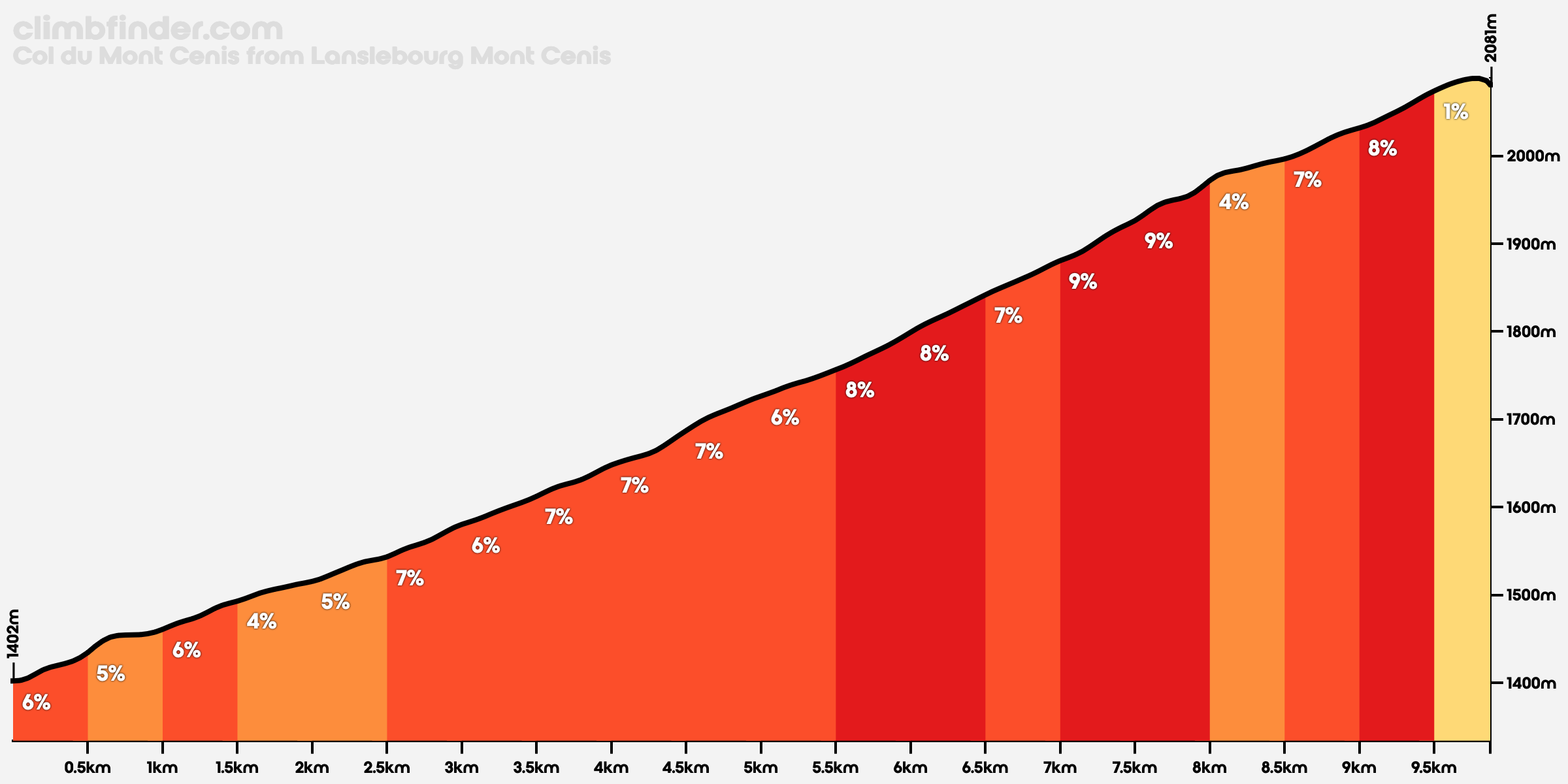
From the French side, Mont Cenis is a short, high-starting ascent from Lanslebourg, little more than 10 kilometres long and fairly regular throughout.
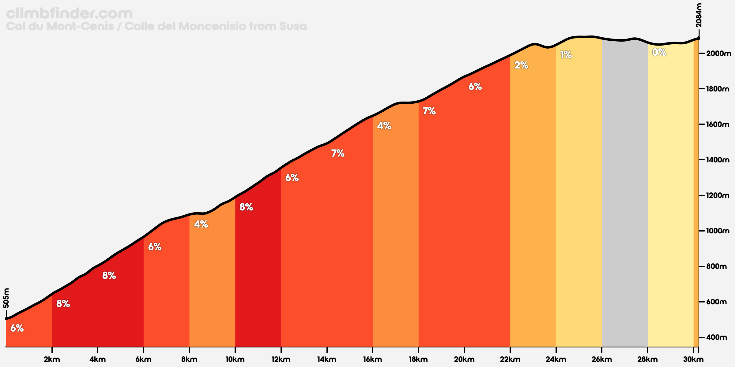
From Italy, it becomes a very different undertaking: a long climb from Susa, whether you take the more direct line or the longer and quieter variant via Moncenisio.
The result is a pass that is not especially theatrical by Alpine standards, but much more interesting than you might expect at first glance.
Seasonal notes
The pass is usually open from mid‑May to mid‑November, with winter closure due to snow.
Once open, conditions on the plateau can still differ from the valleys below. This matters more from the Italian side, where you start in a often warm / hot valley as opposed to the already cooler French start at high altitude.
France vs Italy
Contrasting ascents across a national border
From Lanslebourg, Mont Cenis is direct and predictable: a short, regular climb, starting already high at 1,400 m. It is ridden at a steady rhythm, without much to think about.
The interesting part comes after the pass, once the road opens onto the plateau. That is where Mont Cenis actually begins.
From Susa, Colle del Moncenisio is something else entirely. Even the standard approach is over 30 km with more than 1,500 m of climbing, starting from 500 m. The longer variant pushes this close to 38 km and nearly 1,800 m of D+.
That asymmetry matters and it’s not just a contrast in scenery.
French ascent
A straightforward climb on a wide road. The gradient rarely changes, and the effort is consistent from bottom to top. It is not difficult by Alpine standards.
Tour de France
The Col du Mont Cenis is not one of the Tour’s defining climbs, but it does have race history. It first appeared in the Tour de France in 1949 and has been climbed five times in total, most recently in 1999.
That relative rarity is part of the pass’s character. Unlike Galibier, Iseran, or Tourmalet, Mont Cenis is better known as a historic crossing that occasionally hosts cycle racing than as a climb whose identity was created by it.
Italian ascent
The standard Italian side is long without being extreme. The gradients are manageable, but the length defines the ride. You climb through the valley, break it into sections, and only reach the high open terrain late.
This is the side that makes Mont Cenis feel like a crossing and I cycled it in stage 7 of my Tour de France 2017.
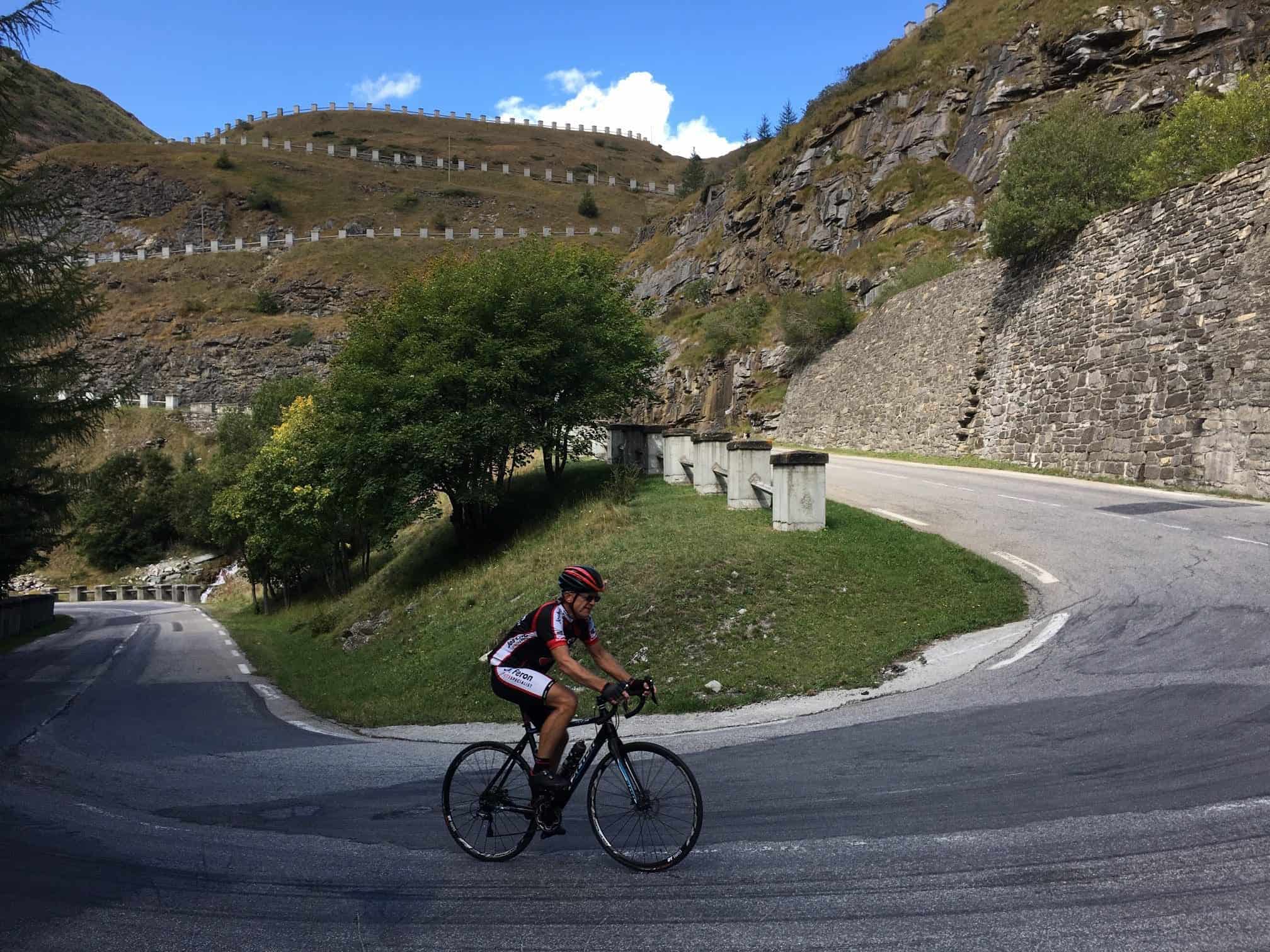
For me, the best part of this ascent was after crossing into France: a long straight along the Pas du Pardis saddle ends in a beautiful series of hairpins.
Via Moncenisio
This is the better way up from Susa. Instead of staying on the main road, you pass through Novalesa and Moncenisio, climbing on a narrower, quieter route with steeper ramps before rejoining the main ascent higher up.
It adds distance, removes traffic, and turns the climb into something more varied. The plateau still comes late, but you arrive there having climbed it properly.
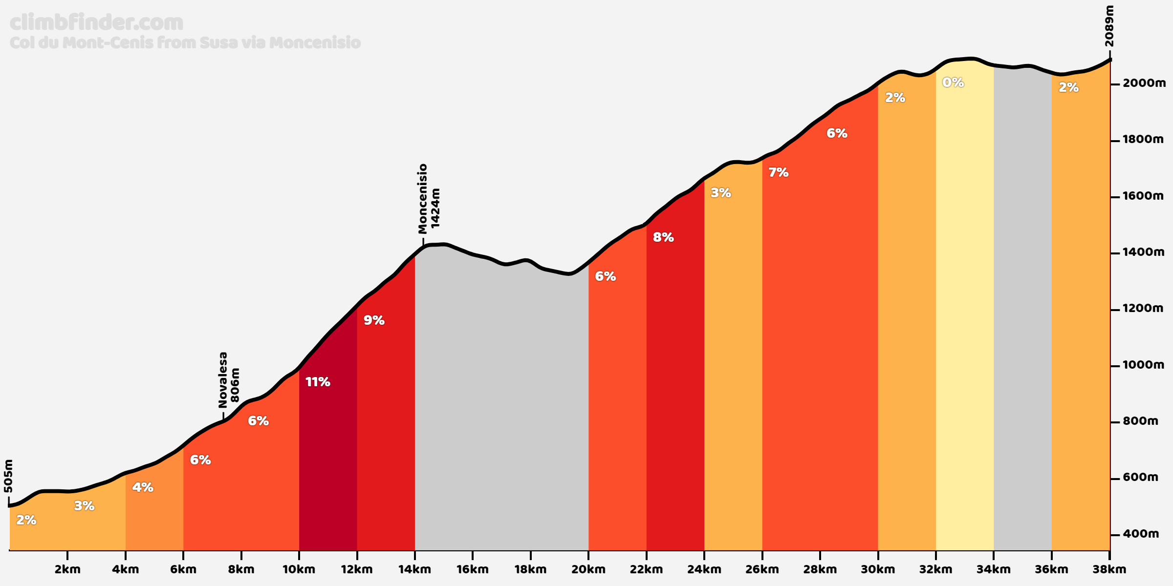
I wasn’t aware of this route at the time, and I just followed the signs from Susa, taking the standard route. In Predonio, at the T-split where you should leave the standard route, there’s a Moncenisio sign pointing straight ahead; for this route, turn right and follow the sign to Venaus / Novalesa onto the SP210, Via Novalesa.
Giro d’Italia
Moncenisio was included twice in the 2013 Giro d’Italia, on consecutive mountain stages.
On Stage 15, the race climbed the pass from Italy into France on the way to the Galibier, stage 16 crossed Mont Cenis in the opposite direction, from Valloire, France back into Italy.
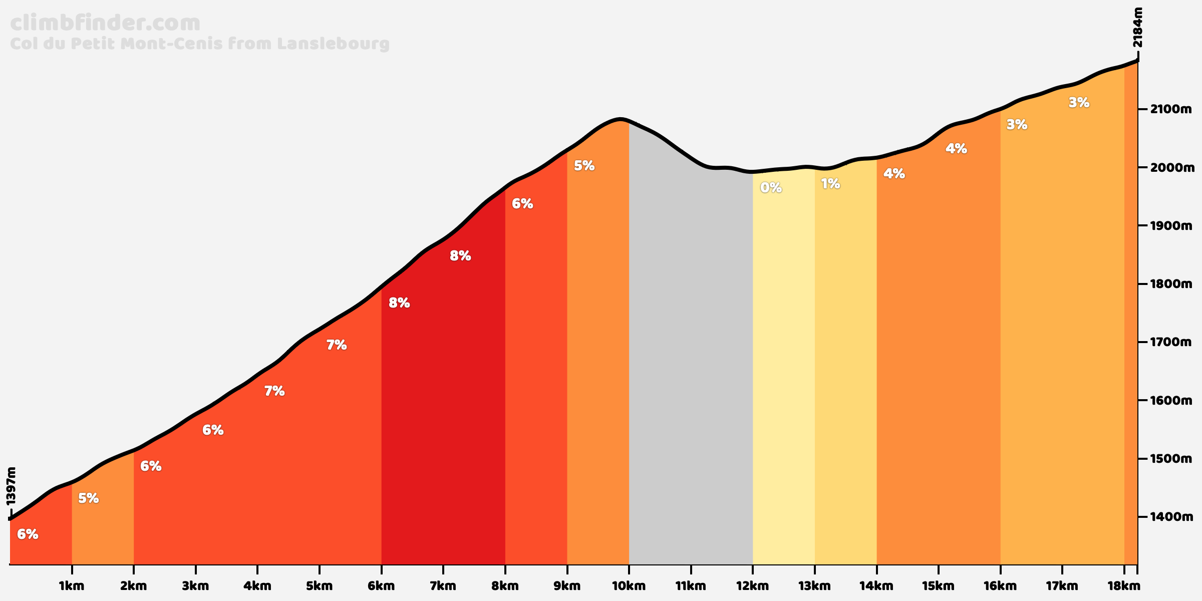
Bonus: Col du Petit Mont Cenis
From the main pass, there’s an extension, the Petit Mont Cenis, which is a bit of an odd name, as it is higher than the Mont Cenis.
There’s no sign pointing to it, but after the refuge at the summit, there’s a parking to the right where a narrow road branches off near the lake. It runs for around 8 kilometers into a quieter valley, finishing at 2,184 meters.
You first descend for around 2 kilometers, then take a near 180-degree turn right to switch to the other side of the lake and climb for another 4 kilometers.
There’s a refuge just off the road there as well.