
The Col de la Croix de Fer (2,067 meters) located in the Savoie department of the Auvergne-Rhône-Alpes region.
While the summit is located in the Savoie, it connects the Savoie to the Isère region.
Its “twin” is the Glandon and the two summits are 2.5 kilometers apart. The western approach for both starts in Rochetaillée, but the Glandon from the (north)east starts in Saint-Étienne-de-Cuines, whereas the Croix-de-Fer starts in Saint-Jean-de-Maurienne.
The area – on both sides – attracts many cyclists, as there are plenty of famous climbs to be found, besides this one.
In Isère – centred around Bourg-d’Oisans – these include the Lautaret, Les Deux Alps, la Bérarde and “the most famous of them all”, the Alpe d’Huez.
In the Savoie region, centred around Saint-Jean-de-Maurienne, you’ll find – among others – the Glandon, Télégraphe / Galibier and the Madeleine.
Tour de France
The Col de la Croix de Fer has featured in the Tour de France 21 times since 1947, most recently in 2022.
In 2015 it was included in 2 stages: stage 19 via the Col du Glandon from la Chambre and stage 20 from Saint-Jean-de-Maurienne.
The latter stage was the result of an alteration, since the original stage route over the Télégraphe / Galibier was blocked because a landslide had made descending the Lautaret impossible.
In stage 18, the climb from Rochetaillée was included too, but that took the left turn over the Glandon…
Saint-Jean-de-Maurienne
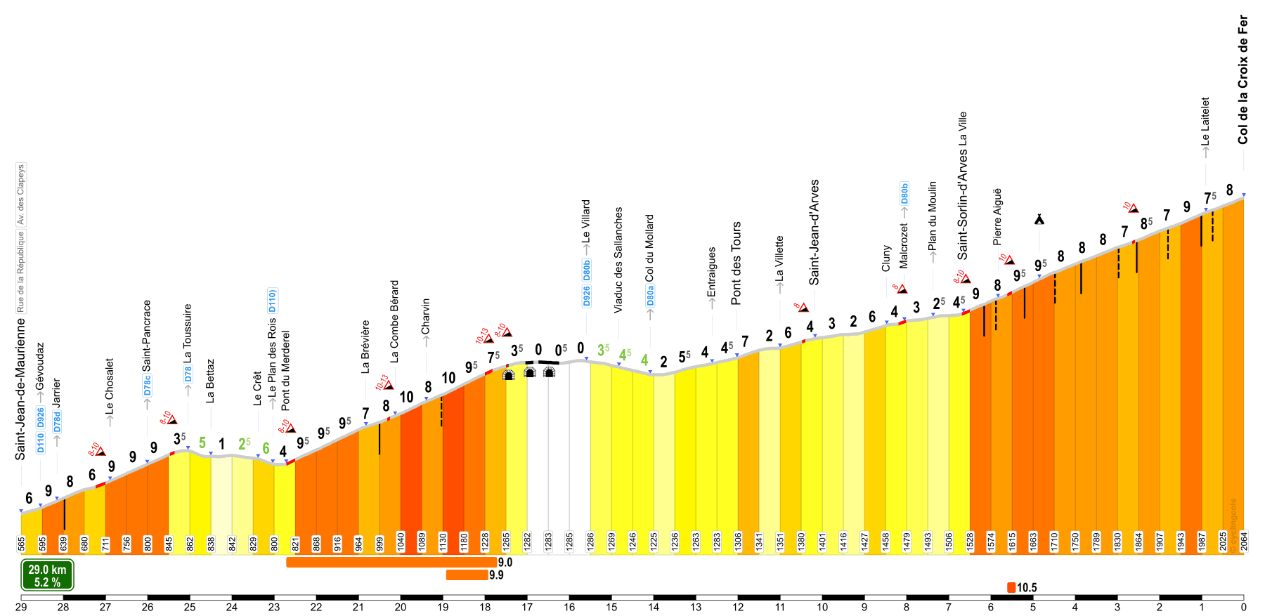
The eastern approach from Saint-Jean-de-Maurienne is 29 km long, with an average gradient of 5.2%.
There are a few flatter sections in the route, totalling some 9 kilometers, including just over 100 meters (D+) of descend.
This increases the climbing parts’ average to around 8.7%…
Just past a series of 3 tunnels, you can take a scenic detour from the classic Col de la Croix de Fer route.
Take the right turn over the D80B, direction Saint-Jean-d’Arves (la Tour / la Chal) / labeled “Route Panoramique”.
It rejoins the “classic” route at Malcrozet.
I barely managed the classic ascend of the Col de la Croix de Fer in 2012, when I was recovering from a bad crash.
The Alpe d’HuZes team trained in the area for a few days and some of us combined this with the climb up the Alpe d’Huez.
At the time, it had only just opened up, but the summit was snow covered and freezing cold, the descent a menace to anyone’s health.
Still, the views higher up are fantastic and this climb should be on your “to do” list.
I revisited it during my Tour de France 2021 stage 4 and the epilogue (panoramic route).
In 2022, it was my epilogue again.
At the summit of the Col de la Croix de Fer, there’s a restaurant and souvenir shop.
That is, there was nothing in 2012 and I believe that had been, and remained, the case for a while.
In 2021 and 2022 it was a sight for sore eyes and I enjoyed the best homemade blueberry pie ever there, which is why I came back twice.
I did get up the Croix de Fer in 2024 too, but that was with a “detour” up and down La Toussuire first and I didn’t pause at the summit.
Note: when you descend the Croix de Fer to Allemont, the hairpin section from the Olle up to Le Rivier actually has a segment of its own, La Côte des Sagnes, marked in the map above.
See the description of the southwestern ascend below for an explanation of how this “detour” came to be.
And from Rochetaillée
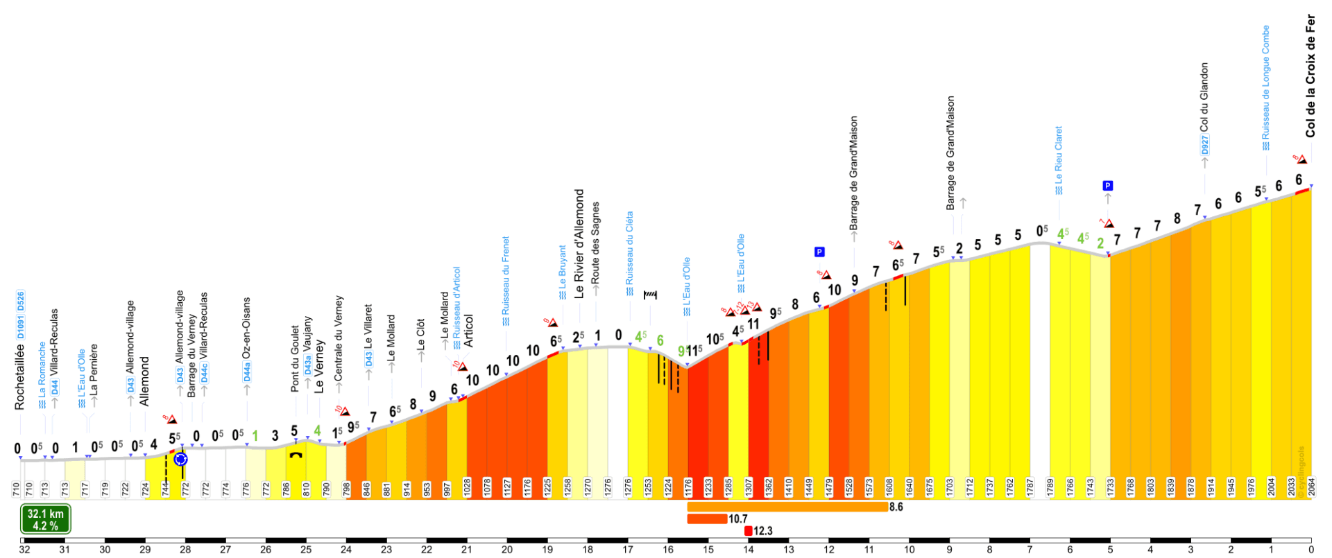
The southwestern end of the Col de la Croix de Fer starts in Rochetaillée.
After a flat warm up of some 3.5 kilometers and a short sprint up the barrage du Verney, the actual climb starts.
From there it’s 29 kilometers in length, with a moderate average gradient of 5.1%.
But other than the first four kilometers, the rest are all but modest…
This end has a serious drop and 13 (!) kilometers with no net elevation gain.
This drop is due to a 1989 landslide that swept away the road (right bank of the Eau d’Olle) above the Rivier d’Allemond at the Maupas waterfall.
The road was then rebuilt on the left bank over 2 km, with this descent to cross the torrent and then a steep (11%) ascent.
The old road can still be seen along the right bank of the mountain.
Taking this drop into consideration, the average climbing gradient rises to around 8.3%…
The toughest parts are just before Le Rivier and after the longer drop, crossing the Olle.
The long 8 to 12% straight after that, is followed by another (very) short drop, after which it gets over 10% again…
This part, leading up to the barrage and the breathtaking view on the Lac de Grand Maison, is also the only part were you will find some picture worthy hairpins.
Other than the three in the first drop just before it that is…
After the Lac, there’s another short downhill, before the last part of Col de la Croix de Fer.
About 3 kilometers before the summit, you’ll pass the left turn up the final 200 meters of the Glandon.
Although the average gradient on the “home stretch” is only just over 6%, the wind can make those final kilometers of the Col de la Croix de Fer quite hard.
I climbed this end in 2014, including the short detour to the top of the Glandon – I descended by car to Saint-Michel-de-Maurienne to continue my ride up the Télégraphe and Galibier…
During my Tour de France 2021, the Col de la Croix de Fer was combined with the Mollard in my prologue.
In the Marmotte of my Tour de France 2022, I cycled this end from Allemond and from Le Verney in stage 6, after I cycled up and down the Col du Sabot.
However, I turned left at the Glandon split on both occasions to have a flying descend back to our apartment.
Alternatives
Col du Glandon
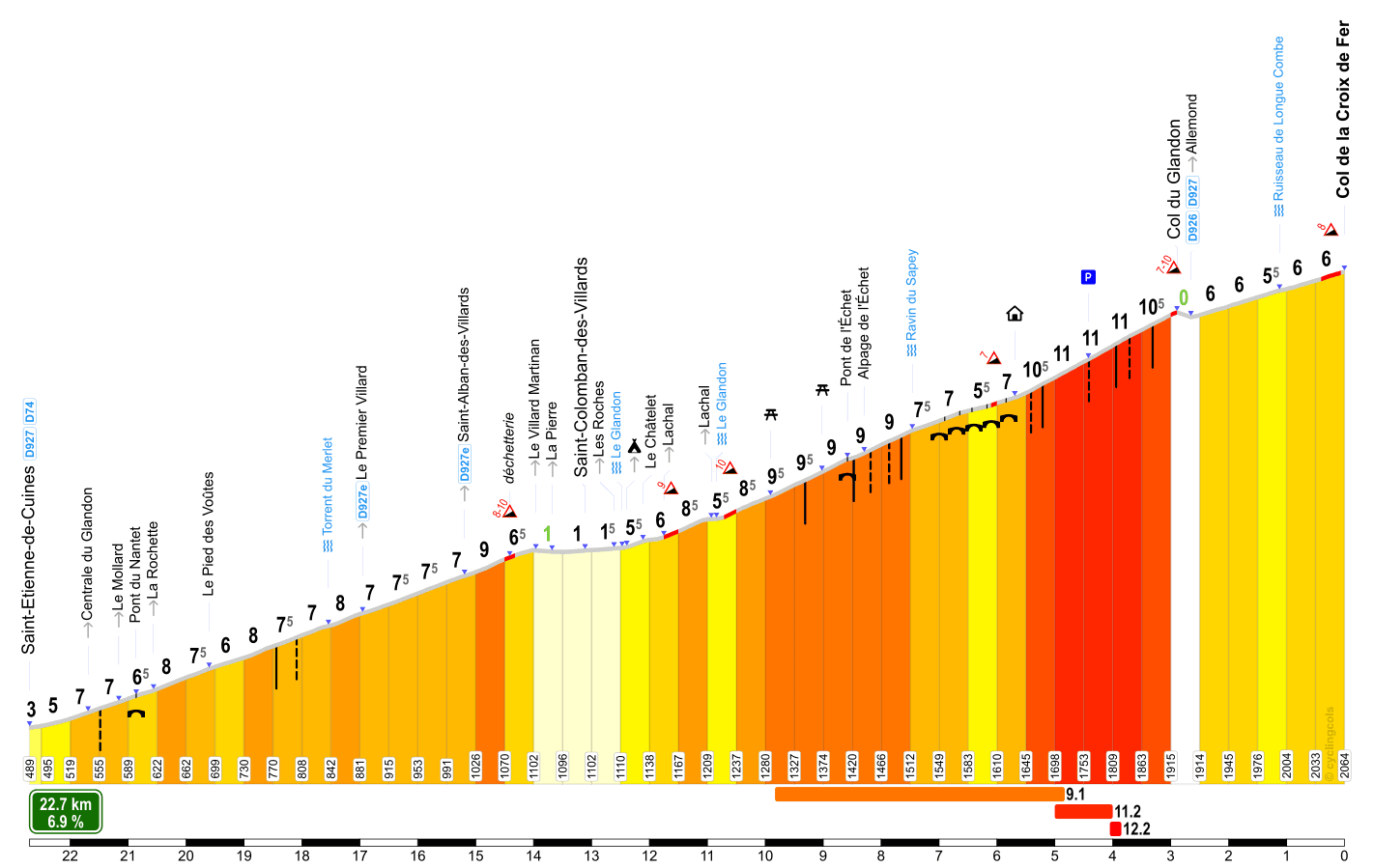
This alternative route of the Col de la Croix de Fer, starting in Saint-Étienne-de-Cuines, goes via the Glandon (1,925m).
The final 2.5 kilometers of the Glandon are often referred to as “hairpin heaven”, but they are also painfully steep, averaging 11%.
After the summit, at around 20 kilometers, it connects to the Croix de Fer for the final ~2.5 kms from the Rochetaillee ascend.
At the Glandon summit, there’s nothing to be had, except for the stunning view down to where you came from.
Although there’s a little shed which offers refreshments – but nothing fresh made – if open.
I’ve only seen it open once, in 2022, and the English lady tending it was very friendly.
I rode up to the summit of the Glandon from this end on my way to our one night stopover near Vaujany in 2014.
It was preceded by the climb up the Madeleine (from Feissons-sur-Isère) and even while I did read the profile card before, it still managed to completely wear me out…
During my Tour de France 2021, I cycled up this end again during stage 2.

Col du Mollard
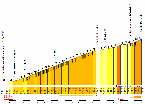
Another route up the Col de la Croix de Fer leads over the Col du Mollard (1,638m).
You can chose to start in Villargondran and take the D80, or take the D110 out of Saint-Jean-de-Maurienne.
The latter joins the route over the D80 at Albiez-les-Vieux and both join the classic route at Belleville.
Unlike the Glandon, the summit of the Mollard is not close to that of the Croix de Fer.
First, you descend around 6 kilometers back to the Croix de Fer route (D926).
From there, it’s some 14 kilometers to the summit of the Col de la Croix de Fer.
Cycling the D110, the Mollard is 17.7 kilometers long, at an average gradient of 6%, although two-thirds of it is close to 8%.
The 20.9 kilometers long ascend over the D80 averages 5.5%, is more regular and it has only a few stretches that are steeper.
This is also the route with an abundance of hairpins – I tried counting, lost count at 36 but Climbfinder states there are 45…
You get a “free” col marker when reaching Albiez-le-Jeune, the Col de la Confrérie (1,368m).
The Mollard can also be included when going in the opposite direction, i.e. not descend the full length of the Croix de Fer, but take the fork over the Mollard at Belleville.
This is also often the case when a Tour de France stage goes on to pass over the Galibier or heads for Modane.
This climb is some 6 kilometers long, at an average of 6.8%.
I tackled the Mollard twice during my Tour de France 2021, from Montrond after the Croix de Fer during my prologue, and from Villargondran during stage 6.


