The pass of the Col du Galibier (2,645 metres) is located in the southern region of the French Dauphiné Alps.
The tunnel at 2,556 meters used to be the only through road until 1976.
When the tunnel was closed for restoration, a loop around the summit, similar to the one over the Bonette, was constructed.
This reaches the ‘official’ summit of 2,645 meters.
With this loop included, it claims 9th spot in the highest paved European roads list, and 5th spot of highest mountain passes.
Without it, it’s ranked 11th and 6th respectively.
Like all passes in the area, it’s closed during winter, roughly between October and June.
What makes climbing the Galibier hard, is the distance.
It can only be reached via the Col du Télégraphe from Saint-Michel-de-Maurienne, or via the Col du Lautaret from either Briançon or Bourg-d’Oisans (Le Clapier).
I cycled up the Lautaret side from Le Clapier on June 9th, 2012 and found the final loop closed from the Valloire end.
Luckily, I could still cycle up from my end, after which I returned to the Lauteret end and continued by car through the tunnel.
When I tackled the northern ascent in 2014, as well as when I combined it with the Lautaret from Briançon in 2017, the road was free of snow, but in 2017, it was freezing cold up there.
I revisited the Galibier from the north during my Tour de France 2021.
That year I cycled the Marmotte, albeit I started and ended in Saint-Jean-de-Maurienne.
Tour de France
The Col du Galibier was first cycled in the Tour de France in 1911 and has been a regular appearance in a Tour stage ever since.
Post WWII, the Col de Galibier was included 31 times in the Tour de France.
On a few more occasions it was scheduled to be included, but was left out at the last minute.
It has also been crossed twice in a Tour, in 2011’s 100th-Anniversary and 2022.
The 2015 double was cancelled due to the collapse of the Chambon tunnel in the Lautaret descend.
In the last stretch towards the tunnel, coming from the south, there is a monument in honor of Henri Desgrange, instigator and first director of the Tour de France.
The memorial was inaugurated in 1949 and whenever the tour crosses the Col du Galibier, a wreath is laid on the memorial.
The first rider to cross the summit when it’s in a Tour stage, is likely to get the Souvenir Henri Desgrange.
This is awarded to the first rider across the summit of the highest mountain in each year’s tour.
This usually is either the Iseran, the Bonette or the Galibier, but the former two each only appeared in a Tour stage 5 times…
North side
 The approach from the north, over the Télégraphe, is 35.1 kilometers long, starting in Saint-Michel-de-Maurienne.
At 12.1 kilometers in length, with an elevation of 852 meters (7%), the preceding Télégraphe is not to be mistaken as a merely a warming up for the Galibier.
After a short descend into Valloire, the actual ascend of the Galibier starts: 18.1 kilometers, with 1,245 meters of elevation, or a 6.9% average.
That may seem almost friendly, but the final 8 kilometers of it averages around 8.4% and the final kilometer – the loop over the tunnel – has an average of over 10%.
You may need a few seconds to recover, before being able to fully appreciate the incredible view you have from up there – I know I did.
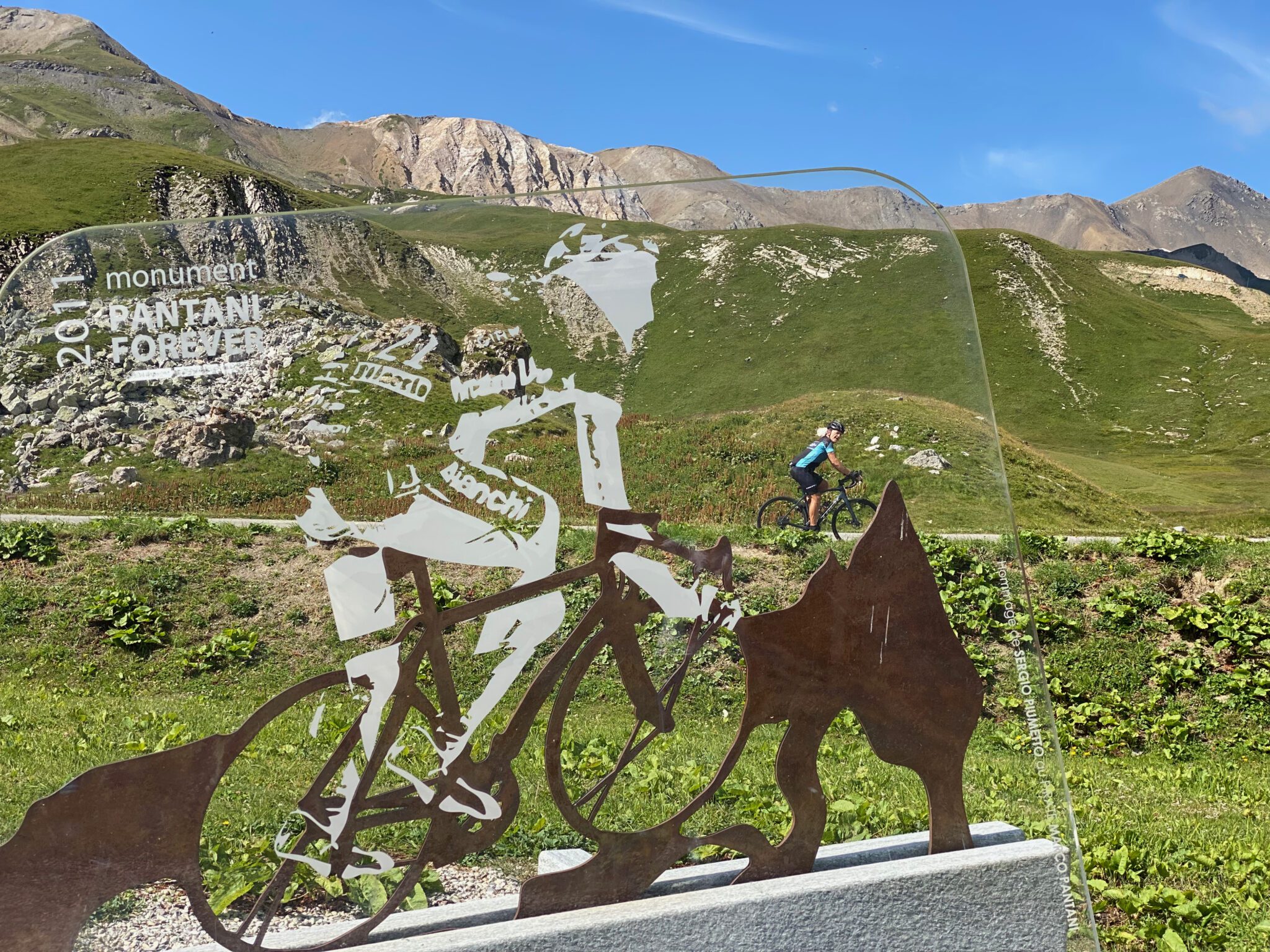
About halfway up the final, some 4 kilometers from the tunnel, there is a monument in honor of Marco Pantani.
It’s located at the right side of the road and you may miss it if you don’t know where to look, as it is a positioned in a field just off the road.
As soon as you reach the scattered buildings at Les Granges, you’re near it.
It is just opposite the sign with the cow (reading Fromage Beaufort or something), before the road turns to the right again.
The Col Collective have produced a video of this ascent, starting in Valloire and in 2021’s Tour, this end was part of my Marmotte,
South side
 From this end, you can only get to the summit of the Galibier by first climbing the Lautaret.
To the summit of the Lautaret, the approach from Briançon (south-east) is 27.7 km long, with 876 meters of elevation at an average of 3.1%.
The ascent of the Lautaret from the south-west, starting at le Clapier, is 34.1 kilometers long, with 1,416 meters of elevation at an average of 3.9%.
Either average is a little deceiving, as from le Clapier there is a drop between kilometers 4 and 6, and like from Briançon, there’s a lot of false flat.
 However, the grades do not exceed 7% very often.
The final stretch of the Galibier itself, from either approach, is 8.5 kilometers from the summit of the Lautaret.
With an altimeter gain of 585 meters (6.9%) it’s similar to, but a little easier than, the ascent from Valloire.
Also from this end, the final up the loop is steep, at an average of 11%…
During my Tour de France of 2014 I cycled this end – in 2017, I cycled it again, as well as the one from Briançon – recap of that Tour here.
in 2022, the Lautaret (le Clapier) end was in my Prologue.