
Now that our short trip to sunny Egypt has ended and May is coming to a close, the start of my Tour de Suisse 2019 is only two months away.
Although I’m back to a regular – much less intense destructive than in 2018 – training routine, I’m still a long way from anything near my ‘normal’ form.
On average, my power numbers are 30 Watts lower than they used to be before my injuries forced me to take a 3-month break.
With the help of Pav from Direct Power Coaching, or Spokes Fit as they are now rebranded, I successfully rebooted, following two training plans.
During that reboot, I reconnected with Xert and I’m now using their ‘adaptive training advisor’ to get me further back on track.
Anyway, the apartments for the Tour de Suisse have been booked, Chesa Bellaval in Silvaplana and Casa Nacla in Sedrun/Surrein.
Both apartments are chosen based on their strategic location, while still staying within a more or less ‘sane’ budget for the tour.
From either place, a score of cols is available for me to break my legs on…
In this post, I’m covering part 1, the week in Silvaplana.
Prologue
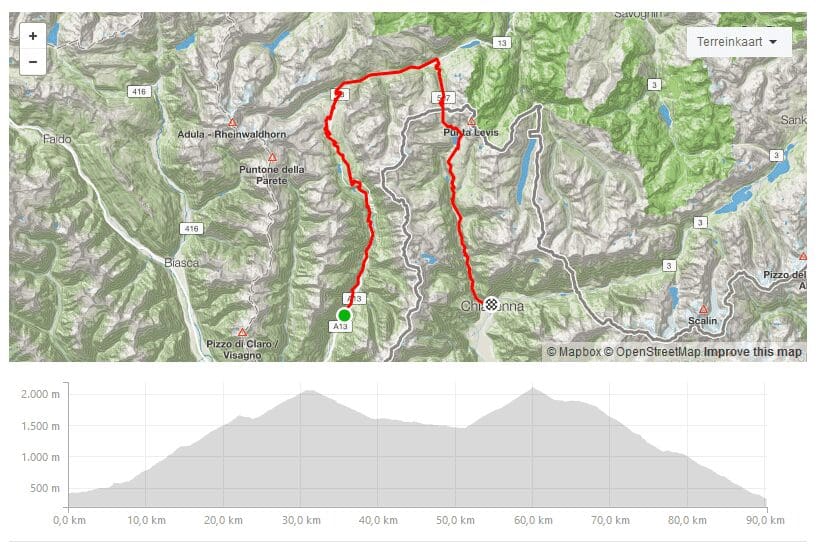
My Tour de Suisse 2019 will start with a prologue including the San Bernardino and the Splügenpass.
The San Bernadino (2,065 m) will be climbed from the south.
I will probably get on my bike in Lostallo, for a warm up before taking on the bulk of the climb, starting in Soazza.
From there, it’s 25 kilometers to the summit, with some 1,500 meters of elevation.
After that, it’s 20 kilometer, mostly downhill, to Splügen.
The Splügenpass (2,114 m) is 9 kilometers long from that end, with an elevation of just under 700 meters.
Another 30 kilometer downhill will then bring me to Chiavenna – depending on how I feel I may continue to the apartment in Silvaplana by bike, tackling the Malojapass (1,815 m) also.
The Maloja is quite unique in that it has only one side to climb – from its summit up to Zernez, 50 kilometers further on, the altitude only drops some 350 meters.
But as including the Maloja would mean another 32 kilometers of climbing, with 1,500 meters of elevation again, the smarter option would probably be to get in the car somewhere during the downhill towards Chiavenna.
On the other hand, getting back to Chiavenna another day, is going to be hard to plan…

Silvaplana
Silvaplana itself is at the foot of the climb up the Julierpass, which connects to the Albulapass on the other end, down in Albula/Tiefencastel.
A bit north of Silvaplana, at Samedan, you have the climb up the Berninapass from the ‘easy’ side.
Further on, at La Punt-Chamues, you can get up the Albulapass from the east.
Even further north of Silvaplana, you get to Zernez, which is at the base of the Ofenpass, connecting to the Umbrail – and Stelvio – in Santa Maria (Val Müstair).
And last but not least, from Susch you can get up the east side of the Flüelapass – the ascent from the west starts in Davos, which can be reached starting in Tiefencastel too.
Stages – passes in the area
Although distances may seem small on the (main) map, I quickly found out that constructing round trips, incorporating two or more of the passes in the area, mostly result in stages as long as the Dreiländergiro.
While a race like that is – besides heroic – obviously doable, I intend to ride as many days as possible.
Unless I can get myself into the shape of a 28-year old UCI pro cyclist, I reluctantly have to commit to shorter daily stages.
For instance, a round trip with the Flüela and the Albula, from Tiefencastel and not Silvaplana, is 125 kilometers long, with some 3,000 meters of elevation difference.
The same stage could also start in La Punt and/or – for the reverse direction – in Susch.
A trip covering both the Julier and the Albula is 100+ kilometers long, with some 2,400 meters of elevation.
Clock- or counterclockwise, that can be done starting in Silvaplana and either alternative seems more doable, but still.
From Silvaplana and La Punt, the Julier and Albula climbs are a lot shorter.
This is mainly because Silvaplana is located at 1,800 (!) meters and la Punt at 1,680 meters.
The Julier (2,284 m) is 7+ kilometers long, with 485 meters of elevation difference.
From Tiefencastel, it is no less than 36 kilometers, with 1,500 meters of elevation difference, with the opening 4 kilometers and several other stretches at well over 8%.
The Albula (2,315 m) is 9 kilometers long from La Punt, but 6 of those are really tough at an average of nearly 10%.
From Tiefencastel it’s over 30 kilometers with 1,550 meters of elevation difference, but that offers several tough stretches at 10% average as well.
The climb up the Flüela (2,383 m) is similar from either end: Susch is located at 1,420 meters, Davos at 1,560 and the climbs are both 13 kilometers long, the one from Susch being the tougher at an average of 7.3% against 6.4% from Davos.
However, to get to Davos, for example starting in Tiefencastel, located at 850 meters, you have to climb an additional 35 kilometers with some 1,000 meters of elevation difference, including an in between drop of 200 meters.
Looking east of Silvaplana, you have the Bernina (2,328 m) starting in Samedan and the Ofenpass (2,149 m) starting in Zernez.
I climbed the Bernina from both ends – the other end starting in Tirano, Italy – during my Giro d’Italia of 2015.
From Samedan it’s basically a recovery ride, like the Larche in France, with 18 kilometers and just over 600 meters of elevation difference.
The Umbrail is another climb I would want to do again, not in the least because it will bring me to the top of the Stelvio too.
Obviously, one will never get tired of the Stelvio 🙂
When the Umbrail is extended with the final 3 kilometers of the Stelvio from Bormio, the total length is 16.5 kilometers, with over 1,400 meters of elevation.
The official average is 8.4%, but that is deceiving, as it is influenced by a small drop and 2 mildly easier kilometers.
So, most of it is 9% and I sure hope that I will not have to face blistering headwinds during the upper half…
Going down the Umbrail again, will give me the opportunity to climb the other (east) end of the Ofenpass on the return.
Officially, that climb starts in Glorenza, but up to Santa Maria, about halfway, it offers only 440 meters of elevation, while the top half offers some 800.
As Silvaplana is – deceivingly – close to the Swiss/Italian border and Tirano or Bormio, I’m keeping the option open to tackle the Mortirolo from Grosio or Sondalo once more.
However, I might save me that trouble and see if I can include Juf (2,126 m), Lenzerheide (1,551 m – two alternatives from Tiefencastel) and/or Arosa (1,897 m).
All three require a transfer by car first too.
Besides, stages covering both ends of any climb near Silvaplana in one go, are all some 80 kilometers long with 2,500 meters of elevation difference each.
Those will already prove to be challenging enough for the first week of my Tour de Suisse…